Identifying Subsurface Materials with Geophysical Methods
Posted on Wednesday, June 8th, 2016 by Affinis CorpIn Project Strategies, tagged in Tags: geophysical surveying, geotechnical engineering, subsurface materials
Determining what lies beneath the surface of our roads is an important part of creating safe thoroughfares and streets. Used to identify subsurface materials, geotechnical engineering can do just that. Some common applications are:
- Characterizing subsurface materials, like bedrock depth, rock type, layer boundaries, water table, groundwater flow, locating fractures, weak zones, expansive clays, and seepage through dams and levees
- Discovering the engineering properties of earth materials. This could mean evaluating stiffness, density, electrical resistivity and porosity.
- Finding highway subsidence. One example is detecting cavities beneath roadways caused by sinkholes or abandoned mines.
- Locating buried manmade objects. These could include, but are not limited to buried utilities, underground storage tanks, and abandoned landfills.
Investigations can be shallow (less than 100 feet) or deep (several thousand feet). Geophysical methods are typically portable and provide access for investigations that drilling does not. Surveys are typically performed from the ground surface, within boreholes, water, and air. They can be a very economical investigation tool.
Geophysical methods allows for capturing hazards that can be missed from typical bore hole investigations. Rather than a point source data point (bore hole), using a geophysical approach you can map large areas between bore holes. This allows for capturing more data and allowing for better mapping/characterization of the subsurface.
This PDF provides a quick summary of the applications, strengths, and weaknesses of each method.
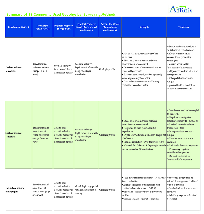
Download the full Geophyiscal Application Table here.