How PCSWMM Improves Project Analysis
Posted on Wednesday, April 20th, 2022 by Affinis CorpIn Stormwater, tagged in

PCSWMM supports the comprehensive analysis of existing stormwater systems. It can provide cities with the ability to target and identify key components for upgrade. Communities can use this information to maximize their budget and prioritize projects, while protecting residents.
PCSWMM allows our team to easily create hydraulic models using a variety of data sources. We start by collecting data from cities via GIS and then, supplement the data with findings from our survey team. That information can be exported quickly into PCSWMM. Then, we can use it to run different storm events, such as the 10 percent Annual Exceedance Probability (AEP) event or the 1 percent AEP event. PCSWMM provides output tables for each event that can be exported into traditional drainage calculation sheets. Cities can seamlessly use that information for hydraulic analysis.
Another advantage that PCSWMM offers is up-to-date information. By exporting and connecting these drainage output tables from PCSWMM to Excel, the drainage tables remain current, if any change within the model is made. This allows for increased efficiency and confidence that all hydraulic calculations shown are consistent and correct. Previously, Excel drainage tables were completed by manually inputting values into Excel and then, used formulas within cells to calculate desired values. This process took additional time to update, especially if any changes were made to the system, such as moving a structure or adding additional pipes to the stormwater system.
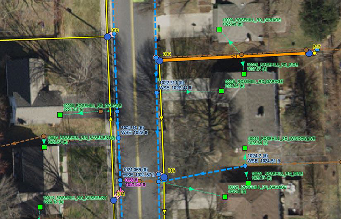
PCSWMM also incorporates the ability to analyze systems that have additional pieces, like tailwater constraints from outlets of the system, flap gates to limit backwater flow, overland flow water surface elevations in streets, and swales. This is valuable, because having the ability to analyze the overland flow water surface elevations, helps us to identify if low opening elevations of adjacent homes are in danger of flooding based on the linked system. The existing model enables us to identify these areas that have flooding concerns and design the proposed system to allow for at least 1 foot of freeboard at these locations to ensure that homeowners are safe within the design parameters. The same concepts apply to street flooding concerns. Using it, we can see the magnitude of ponding water within gutters and centerlines of streets.
Recently, we’ve used PCSWMM on the following stormwater projects:
- City of Olathe, KS: Stagecoach and Sleepy Hollow Stormwater Improvements
- City of Lenexa, KS: Oak Park/Century Estates Storm Improvements
- City of Overland Park, KS: OP 2022 Major Storm Sewer Repair
- City of Prairie Village, KS: Brush Creek at Mission Road and 68th Street Flood Control Project
Overall, PCSWMM provides the ability to increase efficiency. Using it, we can check all parameters given in the process of upgrading an existing system. That data is then provided to the client with additional information regarding flooding concerns of buildings and streets within the project area using a complete node-link connected system. This tool allows our team to support cities in protecting their communities.