Weatherby Lake Improvements
Posted on Wednesday, July 13th, 2016 by Jason DavisIn Our Clients, Stormwater, tagged in Tags: dam, fema, loma, weatherby lake
For nearly 30 years, we have provided professional engineering services to the Weatherby Lake Improvement Company (WLIC). During that time, we have worked on a variety of projects related to the lake, its dam, and the spillway. Some of the services have included:
- Dam inspections
- Lake bottom surveys
- FEMA Letter of Map Amendment (LOMA)
- Spillway repair design
- Dam repair design
- Retaining wall design
- Abutment grouting design
While we’ve completed over 10 projects with WLIC, we selected just four to highlight here.
FEMA Letter of Map Amendment (LOMA):
We completed the LOMA in 2016 that included over 200 property owners located around the perimeter of Weatherby Lake. When the new FEMA map became effective on April 2, 2015, property owners were required to pay the maximum rate for flood insurance regardless of their homes’ location, as the new map did not establish a base flood elevation.
Affinis’ s engineers determined the LOMA Out-As-Shown would be the most economical mechanism to request a LOMA. If a FEMA aerial map shows a home is out of the 100-year limits, then it can be considered “out-as-shown.” The LOMA determined that all but one home was outside of the FEMA 100-year base flood, which allowed property owners to receive flood insurance at a much lower rate.
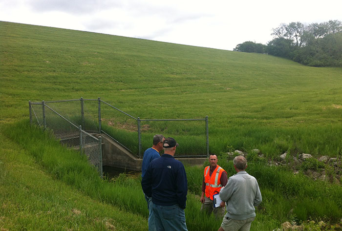
Annual Dam Safety Inspections:
For nearly 15 years, we have performed annual dam safety inspections in accordance with the Missouri Dam and Reservoir Safety Council requirements. The annual inspections include a site assessment of the principal and emergency spillways, slope stability, and toe drain system. During these inspections, our engineers also review operation and maintenance procedures with the owner. An annual report is prepared, and the findings are documented, noting necessary maintenance and improvement needs.
Lake Cross Sections and Sediment Computations:
As part of the lake’s dredging program, our surveyors have taken cross sections at critical coves. These cross sections are used to determine the amount of sediment filling the lake. We complete these at some locations annually and at others bi-annually. WLIC uses this information to check the rate of sediment accumulating, so they can plan and budget for future dredging operations. They do this to maintain the lake’s water quality and functionality.
Bridge Girder Repair:
In 2011, WLIC requested engineering services for the repair of the bridge spanning the spillway. Affinis provided alternatives that allowed WLIC to repair the bridge economically. Making these updates before further degradation occurred helped prevent costly future repairs.
About Jason Davis
Having served in the military, Jason understands the intricacies of federal work. An owner at Affinis, his extensive knowledge makes him a great asset to us, as well as our clients.